Digital urban forest
Protecting and growing our urban forest is a key priority in the City of Unley.
Council has partnered with private industry to pioneer a world-first innovation of building a "digital twin" of our city's trees.
With our industry partner Aerometrex, detailed models of the city's tree canopy were captured by Light Detection and Ranging (LiDAR) imaging technology mounted on planes during aerial flyovers across Unley in 2018 and 2021.
The data was compared across the time interval, with scientific analysis of the models showing us how our urban forest is changing over time and highlighting which factors lead to growth and loss of our trees.
The City of Unley has worked with SA company Forestree to develop the MyCanopy app, allowing visitors to enter a property address within the City of Unley and view information about tree canopy change.
Launch MyCanopy
This is part of our work to help keep Unley leafy for future generations through the Tree Strategy(PDF, 9MB) .
Frequently Asked Questions
How is the tree canopy data collected?
Council partnered with Aerometrex to create a tree canopy map of our city using Light Detection and Ranging (LiDAR), which uses laser pulses from an overflying plane.
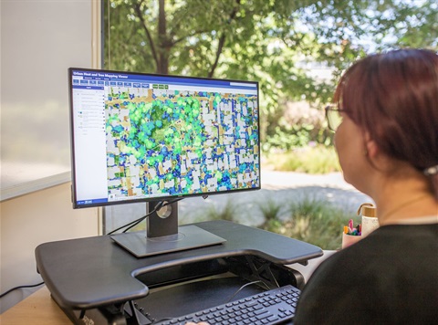
Only canopy 3m or taller was captured across both public and private land. The results create a 3-D map of the canopy cover to a 10cm resolution. The image at the top of this page gives you a great example of the level of detail created.
Council then used Geographic Information Systems (GIS) to overlay each LIDAR dataset over property boundaries to give individual property detail.
When was the tree canopy measured?
Data was collected in April 2018 and April 2021 to track the progress of our tree canopy cover over time.
Due to the number of laser pulses picking up branches as well as leaves to create the 3-D canopy map, it still gives a reliable result even if some deciduous trees were starting to lose their leaves at the time of capture. The image as the top of this page gives a good indication of the level of detail picked up.
How is the canopy cover % calculated for my property?
The tree canopy coverage % is calculated using:
- The total area of the individual property
- The total area covered by canopy (only canopy 3m or taller is captured) captured using LiDAR technology.
Council then used Geographic Information Systems (GIS) to overlay the LIDAR canopy results with each individual property. This provides each property's individual canopy coverage result as a percentage.
For example. If your property is 500m2, and the canopy cover was 50m2 your total canopy cover percentage is 10%.
Why is the City of Unley collecting this data?
Improving data management is a key part of Council’s Tree Strategy, which aims to create a resilient, healthy, and diverse urban forest to keep Unley leafy for future generations.
Looking at the information by street and suburb will enable a targeted approach to implementing Council’s Tree Strategy work.
The LiDAR data will support and guide Council toward reaching its overall target of 31% canopy cover by 2045, and guide the Council and the State Government in achieving its canopy cover targets:
- The 30 Year Plan for Greater Adelaide (2017) outlines key directions to create a greener city through an increase in green cover by 20% across metropolitan Adelaide by 2045. This represents an increase from 26% to 31% for Unley.
- The City of Unley Tree Strategy has a matching goal of a 20% increase in green cover by 2045.
The LiDAR data will also support Council’s proactive advocacy at the state level to influence change in the Planning and Design Code.
How is this data being used?
The LiDAR results show that most of the increase in canopy cover is due to established trees growing larger.
Across the whole of City of Unley, we are collectively still losing more trees than recently planted ones due to removal of hazardous or diseased trees, urban development, or infrastructure replacement.
Essentially this means that existing, growing trees are compensating for the trees lost in recent years.
Council staff have started to apply this new data to analyse changes at a whole of Council level.
Analysing the data results will allow Council to track progress and better target future investments.
How has this work been recognised?
As a leading example of industry partnership and government innovation, this work has been recognised with awards, including:
What is tree canopy cover?
Tree canopy cover is the layer formed by the branches, leaves and crowns of trees.
Canopy cover is defined as any tree above 3m in height. While smaller trees and other vegetation also provide many benefits across the city, the 3m height allows direct comparison to the 2018 study set by the State Government and keeps the focus on a height at which trees are expected to start delivering canopy cover benefits. Newly planted trees are unlikely to be 3m or more in height and have therefore been excluded from the analysis.
Why is tree canopy cover important?
Unley is known for its leafy streets and the community recognises the importance trees play in our health and wellbeing.
Leafy streets and gardens can:
- reduce household cooling costs by more than 10%
- attract birds and butterflies to your garden
- provide wildlife habitats
- provide edible fruits and nuts
- improve air quality
- improve human health outcomes, including 16% lower heart disease and stroke rates
- increased property value
- create privacy screens.
Trees in streets, parks and private gardens are one of the most effective methods for reducing heat in urban areas and the adverse effects of climate change.
What is a good level of canopy?
Overall we are aiming for 31% canopy cover by 2045. However we understand that every property is unique and may not have the space for large trees or to plant new ones. Some people also have trees that they keep pruned lower than 3m tall and these would be missed by this LiDAR analysis.
So while the average private property canopy coveage is currently 22.34%, please consider your properties percentage in balance with your unique situation.
The percentages displayed on rates notices are for informative purposes, raise the awareness of the importance of canopy cover city-wide, and encourage residents to keep the trees they already have and plant more trees if possible.
Is there a percentage target?
Council’s commitment is at a city-wide level, aiming to restore canopy cover to a target level of 31% by 2045.
Of course actual percents vary across land use and ownership. For example our leafy city streets and roads currently have an average of 44% tree canopy coverage.
A percentage target at the property level is not set. By providing this data to residents, Council aims to educate and encourage an increase in canopy cover on private land.
Is my neighbours trees / street tree that overhangs my property included in the result?
Yes, an overhanging canopy is included in a property result as it is captured inside the property boundary. The LiDAR shows where the canopy falls over a specific area, but it does not show where the trunk is located.
Can I find out about other properties?
Anyone can access canopy cover information at a city-wide and property level in the City of Unley on the My Canopy app.
What is Council doing for tree canopy cover in public spaces?
Overall we currently have 44% canopy coverage over streets and roads and 28% over other public land.
Environmental Stewardship is a key strategy of the City of Unley – one aim is to maintain and improve Unley’s urban forest.
Our arboriculture team look after our existing park and street tree assets with a combination of inspections, cyclic pruning, maintenance and even clever use of stormwater such as these tree inlets.
To further increase our canopy we have been planting more new trees. For example:
- In the 2020-21 annual budget, Council allocated $160,000 toward planting 440 new trees on public land to increase the canopy cover across the City.
- In the 2021-22 annual budget, one of Council’s key projects was to implement Council’s Tree Strategy, increasing canopy cover across the district through the planting of 275 new trees.
If Council is worried about canopy cover, why are trees allowed to be removed for development?
Council only has powers regarding significant and regulated trees.
Authority, regulation and policy-making rests with the State government, and Council continues to advocate for strengthening of protection for Significant and Regulated Trees.
Where the State Planning Commission is the relevant authority to access and determine development applications, Council can raise concerns over the removal of trees, however the final decision rests with the State Commission Assessment Panel.
You may also be interested in...